| THOROUGHFARE | ||
| Edgware Road | ||
|---|---|---|
| File:EdgwareRoadSS.jpg | ||
| Borough | Westminster | |
| District | - | |
| Length | - | |
| Number Range | - | |
| Type | Commercial | |
| Post Code | W1, W2, NW1, NW2, NW9 | |
| Adjacent Streets | - | |
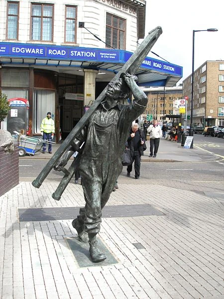
Sculpture "The Window Cleaner" by Allan Sly outside the tube station
Edgware Road is a major street which passes through the west of central London, in the City of Westminster. The southern part of the road, noted for its distinct Arab flavour and many late-night bars and shisha cafes, is known to Londoners by nicknames such as "Little Cairo," "Little Beirut," etc.
The road[]
As a road, it runs north-west from Marble Arch, and as the A5 road, passes underneath Marylebone Road, through Maida Vale, Kilburn and Cricklewood (as Cricklewood Broadway). It is joined by the North Circular Road before West Hendon at Staples Corner. After this, the road continues even further north, through The Hyde, Colindale, Burnt Oak, and finally, to Edgware.
The southernmost part of the road forms part of the London Inner Ring Road and as such is part of the boundary of the London congestion charge zone. However, when the zone was extended in February 2007, the road became part of one of the "free through routes" which allows vehicles to cross the zone during its hours of operation without paying the charge.
Certain stretches of the road are named separately. 'Edgware Road' is used for three such stretches; the other six are known as Maida Vale, Kilburn High Road, Shoot up Hill, Cricklewood Broadway, West Hendon Broadway, and The Hyde Park.
The area[]
As an informal district of London, its southern boundary is Cumberland Gate, just south of Marble Arch and at the north-east corner of Hyde Park. The district's northern boundary is the Marylebone flyover.
The postal codes of the area are W1, W2 and NW1.
The portion of the road stretching between Marble Arch and the Marylebone Flyover also separates the areas of Marylebone and Bayswater.
History[]
Before the Romans, today's Edgware Road began as an ancient trackway within the Great Middlesex Forest. The Romans later incorporated the track into Watling Street.
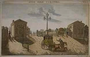
Hyde Park toll gate.
Centuries later, the road was improved by the Edgware-Kilburn turnpike trust in 1711, and a number of the local inns functioned as a stop for coaches, some of which still exist.
During the 18th century, it was a destination for Huguenot migrants. By 1811, Thomas Telford produced a re-design for what was then known as a section of the London to Holyhead road, a redesign considered one of the most important feats of pre-Victorian engineering. Telford's redesign emerged only a year after the area saw the establishment of Great Britain's first Indian restaurant.
The area began to attract Arab migrants in the late 19th century during a period of increased trade with the Ottoman Empire. The trend continued with the arrival of Egyptians in the 1950s, and greatly expanded beginning in the 1970s and continuing to the present when events including the Lebanese Civil War, the overthrow of the Shah of Iran, and unrest in Algeria brought more Arabs to the area. They established the present-day mix of bars and shisha cafes, which make the area known to Londoners by nicknames such as "Little Cairo" and "Little Beirut." These shisha cafés have been hard hit by the enforcement of the England-wide smoking ban [1] in 2007.
One of the two Edgware Road tube stations was one of the sites of the July 7th bombings. A bomb was detonated on a train leaving the tube station serving the Circle, District and Hammersmith & City lines) and heading for Paddington tube station. Six people were killed in the blast: Colin Morley, 52, Jennifer Vanda Ann Nicholson, 22, Johnathan Downey, 34, Laura Webb, 29, Michael Brewster, 52, and David Foulkes, 22. The perpetrator was the ringleader of the July 7th bombings, Mohammed Siddique Khan. On the first anniversary of the bombings, a memorial plaque to the victims was unveiled at the station.
Culture[]
The southernmost part of the road, south of the junction with Marylebone Road, is noted for its distinct Arab flavour. Many Lebanese restaurants and shisha cafes line the street. The Odeon cinema, once the location of the biggest screen in London, often shows films in Arabic.
Edgware Road is unique as a district, rich in ethnic culture, and is known for its high levels of Arab, African, and communities yet also in a very central area of London.
Its present day history and culture of the area is known to be Arabian culture. however, this area has had its fair share of cultures before that like Romanian etc..
In addition to branches of the typical Starbucks, Pret a Manger, Subway and Costa Coffee chains, Edgware Road is home to several Maroush restaurants, a whisky bar named Salt and a large variety of kebab and shawarma restaurants that remain open through the night. Edgware Road is noted for containing within it the famous Church Street Market.
Institutions of note[]
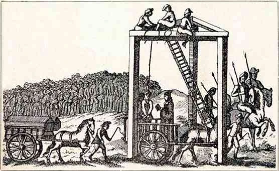
The 'Tyburn tree', once the principal site of executions in London
- A Wetherspoons tavern, The Tyburn, is named after the 'Tyburn tree', once the principal site of execution in London. Today, three golden triangles indicate the location of the tree, at the southernmost end of Edgware Road.
- A Marriott Hotel is situated to the east of the road on George Street, between Marble Arch and the Marylebone flyover.
- The Seymour Leisure Centre lies on Seymour Place.
- The University of London has residences on Brown Street, east of Edgware Road, and in Sussex Gardens and Talbot Square, to its west.
- The York Building is currently under construction. It will house luxury apartments, office space as well as retail area on its ground level.
Nearby stations[]
Mainline rail stations:
London Underground stations: